

Oregon History
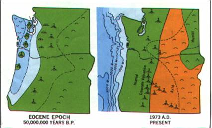
| The
sediments/coastal ranges other than Blue etc. may have always been submerged
such that the volcanic chain may have been on the coast or even an island
chain. Evidence of this can be seen from about 40 mya. |
|
| Something changed
about 35 mya when the subduction line straightened and paralleled what has
become today’s coastline. Volcanics shifted from curve to present day line
parallel to the coast. The shift meant that the former subduction area
stabilized to a new platform. The activity of these early Cascades lasted for
about 10 my. These were explosive eruptions which spread light colored ash
over much of central Oregon. |
|
| About 20 to 25 mya,
the Cascades took a breather and a new eruption occurred in central and then
eastern Oregon. Floods of basalt covered thousands of square miles. Then the
basalt floods stopped about 12 mya and the volcanic activity resumed in the
Cascades. Why? Did the slab of ocean crust break off? |
|
| Faulting and
fracturing in south central and southeast Oregon occurred from starting
between 10 and 15 mya up to the present. The west part of the state is moving
north relative to the rest of the
state. It seems that the floor of the Pacific is moving north and dragging
the western part of the continent with it (as we see with the San Andreas
Fault in Southern California) But in northern California and Oregon it is not
a narrow strip but a broad zone. This could be due to the Juan de Fuca ridge. |
|